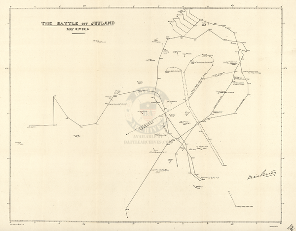
Schlieffen Plan (German Invasion of France) Battle Map
The Schlieffen Plan was the name given after World War 1 to the pre-war planning activities by the Germans in the lead up to World War 1. Field Marshal Alfred von Schlieffen was head of the German General Staff from 1891 to 1906. This plan called for a strong right wing that pushed through Belgium, Luxembourg, and northern France, before turning south towards Paris. When war did break out in August 1914, this plan was used as the blueprint for the invasion, but this has been disputed as the basis for the invasion.
This map shows the German units and area of responsibilities at the start of the invasion when units were attacking west.
Published: Unknown
Dimensions (Width x Height, inches): 19.5x20.3
Our printing is archive-quality.
Each map is printed using the finest materials and methods. Your map will be handled with white gloves from start to finish. We use the Giclee printing method on the finest paper, which produces a clear, extremely detailed, durable map that is perfect to be proudly displayed in your home or office.
About our framing:
- Non-glare acrylic to reduce reflection
- Dry mount to ensure your map is smooth and without wrinkles
- 1.5 inch, 4-ply white mat to accentuate your map
- Black, light walnut, and natural frame color options to match any room
- Wire mounting
- Please note that we cannot refund or return custom framed maps. We can replace a damaged frame. If your frame is damaged, please use the Contact Us or email customercare@battlearchives.com
Digital watermark does not appear on your purchased map