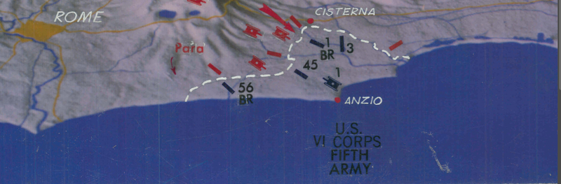


Anzio Beachhead and Italy Battle Map
The amphibious landing at Anzio occurred on 22 January 1944, which is about 50 kilometers (31 miles) south of Rome. After months of stalemate around the landing site, the Allies broke out and captured Rome on June 4th, two days before D-Day at Normandy.
This map has a view of central Italy from the west. The Anzio beach head and units involved are at the center bottom of the map.
Result: Allied Victory
Created/Published: Unknown, declassified 1986
Dimensions (Width x Height): 11x8.7
Our printing is archive-quality.
Each map is printed using the finest materials and methods. Your map will be handled with white gloves from start to finish. We use the Giclee printing method on the finest paper, which produces a clear, extremely detailed, durable map that is perfect to be proudly displayed in your home or office.
About our framing:
- Non-glare acrylic to reduce reflection
- Dry mount to ensure your map is smooth and without wrinkles
- 1.5 inch, 4-ply white mat to accentuate your map
- Black, walnut brown, and natural frame color options to match any room
- Wire mounting
- Please note that we cannot refund or return custom framed maps. We can replace a damaged frame. If your frame is damaged, please use the Contact Us or email customercare@battlearchives.com
Digital watermark does not appear on your purchased map