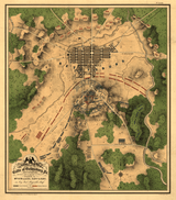


Gettysburg, Pennsylvania - July 2, 1863 Battle Map
Gettysburg, Pennsylvania - July 2, 1863 Battle Map
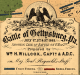
Experience the most pivotal day of America's greatest battle with this detailed 1863 military map of Gettysburg's second day. Created by Captain William H. Willcox, aide-de-camp to Major General John F. Reynolds, this hand-drawn battlefield map documents the fierce fighting that determined the outcome of the Civil War's turning point.
The Critical Second Day
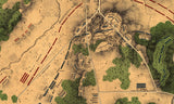
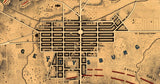
This meticulously hand-drawn map captures July 2, 1863—the day that decided Gettysburg. Every regiment, battery, and defensive position is precisely marked as the battle reached its crescendo. Confederate forces under General Longstreet launched massive assaults against the Union left flank, attacking Little Round Top, Devil's Den, the Peach Orchard, and the Wheatfield in some of the war's most desperate fighting. Union positions are shown in blue, Confederate in red, revealing the tactical situation as Federal forces struggled to hold Cemetery Ridge and the vital high ground. The detailed annotations show unit positions, command structures, and theebb and flow of combat across the blood-soaked Pennsylvania countryside.
Historical Significance
Gettysburg's second day proved decisive in repelling the Confederacy's deepest invasion of the North. The desperate Union defense of Little Round Top by the 20th Maine, the savage fighting in Devil's Den and the Wheatfield, and the ultimately successful holding of Cemetery Ridge set the stage for Pickett's Charge on July 3rd and Lee's eventual retreat. This contemporary map—drawn by a staff officer who witnessed the battle firsthand—provides an authentic military perspective on the day that turned the tide of the Civil War. Within five months, President Lincoln would deliver the Gettysburg Address on this same ground, consecrating it as hallowed soil.
Museum-Quality Reproduction
This is a high-quality reproduction of the original 1863 battlefield map, professionally printed using museum-grade methods and materials to preserve every detail of this historic military document.
Perfect For:
- Civil War enthusiasts and military history collectors
- Students and teachers of American history
- Veterans and those who honor military heritage
- Anyone passionate about preserving our nation's history
- Gift-giving for history buffs and collectors
Specifications:
- Original Publication: 1863
- Cartographer: Captain William H. Willcox, aide-de-camp to Major General John F. Reynolds
- Style: Hand-drawn battlefield map with color-coded forces
- Features: Detailed unit positions, terrain features, and tactical annotations
- Product Type: High-Quality Reproduction Print
Dimensions (Width x Height): 17.9 x 20.5
Each map is printed using the finest materials and methods. Your map will be handled with white gloves from start to finish. We use the Giclee printing method on Hahnemuhle paper, which produces a clear, extremely detailed, durable map that is perfect to be proudly displayed in your home or office.
Digital watermark does not appear on your purchased map.


