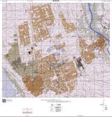
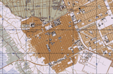
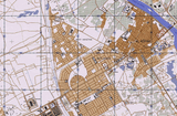


Najaf, Iraq City Topographical Map
Map covering the town of Najaf, about 100 miles (160 kilometers) south of Baghdad. Najaf saw heavy fighting in 2003, 2004, and 2007. Najaf is a city of great importance to Shia Muslims. This topographical map shows great detail on what the city looked like during the 2003 invasion.
Result: American and Allied Nations Victory
Created/Published: 2003
Scale: 15,000
Dimensions (Inches, Width x Height): 18x18.9
Our printing is archive-quality.
Each map is printed using the finest materials and methods. Your map will be handled with white gloves from start to finish. We use the Giclee printing method on the finest paper, which produces a clear, extremely detailed, durable map that is perfect to be proudly displayed in your home or office.
About our framing:
- Non-glare acrylic to reduce reflection
- Dry mount to ensure your map is smooth and without wrinkles
- 1.5 inch, 4-ply white mat to accentuate your map
- Black, walnut brown, and natural frame color options to match any room
- Wire mounting
- Please note that we cannot refund or return custom framed maps. We can replace a damaged frame. If your frame is damaged, please use the Contact Us or email customercare@battlearchives.com
Digital watermark does not appear on your purchased map


