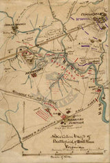
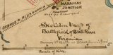
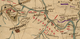
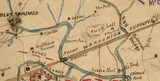


Bull Run (Manassas) I Skeleton Battle Map
The First Battle of Bull Run, or by the Confederates as the First Battle of Manassas, was fought on 21 July 1861. It is considered the first major battle of the Civil War. The Confederate forces of the Army of the Potomac (later renamed the Army of Northern Virginia) under General Beauregard beat the Union Forces of the Army of Northeastern Virginia led by General McDowell. Confederate Brigadier General Thomas Jackson received his nickname "Stonewall" on the field here. The battle took place roughly 25 west of Washington D.C.
This hand drawn map extends south more than the other hand drawn maps on the First Battle of Bull Run Collection. This map includes Manassas Junction in the south and Centreville (spelled Centerville on this map) in the northeast.
Result: Confederate Victory
Created/Published: Unknown, likely between 1861-1865
Dimensions (Width x Height): 20x29.8
Each map is printed using the finest materials and methods. Your map will be handled with white gloves from start to finish. We use the Giclee printing method on Hahnemuhle paper, which produces a clear, extremely detailed, durable map that is perfect to be proudly displayed in your home or office.
Digital watermark does not appear on your purchased map.


