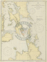
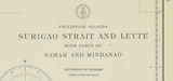
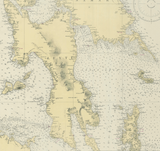
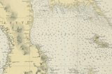


Leyte Gulf, Philippines 1941 USCG Map
Map published by the US Coast Guard in 1936 and updated and reissued in 1941 of the central Philippines, with focus on the water depth around the islands of Leyte, Samar, Bohol, Cebu, Camotes, Mindanao, and Dinagat. The Battle of Leyte Gulf was the largest naval battle in history in terms of tonnage of ships involved, tonnage of ships sunk, and physical size of the engagement area.
Result: American Victory
Created/Published: 1936
Dimensions (Width x Height): 24x32
Our printing is archive-quality.
Each map is printed using the finest materials and methods. Your map will be handled with white gloves from start to finish. We use the Giclee printing method on the finest paper, which produces a clear, extremely detailed, durable map that is perfect to be proudly displayed in your home or office.
About our framing:
- Non-glare acrylic to reduce reflection
- Dry mount to ensure your map is smooth and without wrinkles
- 1.5 inch, 4-ply white mat to accentuate your map
- Black, light walnut, and natural frame color options to match any room
- Wire mounting
- Please note that we cannot refund or return custom framed maps. We can replace a damaged frame. If your frame is damaged, please use the Contact Us or email customercare@battlearchives.com
Digital watermark does not appear on your purchased map


