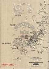
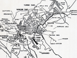
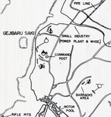


Okinawa Naha Battle Map
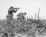
The Battle of Okinawa (Operation Iceberg) was fought from April to June, 1945. The amphibious landings at the outset of the battle was the largest amphibious assault of the Pacific War. Okinawa was the last stop on the Allied island hopping campaign before getting to the Japanese main islands. The US took over 50,000 casualties in the battle.
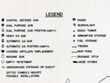
This map focuses on the city and surrounding areas of Naha. Military buildings such as barracks, radio stations, rifle pits, shipyards, and motor pools are designated. This map was published less than a year before the invasion of the island commenced.
Result: American Victory
Published: 1944
Dimensions (Width x Height): 13.7x19
Our printing is archive-quality.
Each map is printed using the finest materials and methods. Your map will be handled with white gloves from start to finish. We use the Giclee printing method on the finest paper, which produces a clear, extremely detailed, durable map that is perfect to be proudly displayed in your home or office.
About our framing:
- Non-glare acrylic to reduce reflection
- Dry mount to ensure your map is smooth and without wrinkles
- 1.5 inch, 4-ply white mat to accentuate your map
- Black, light walnut, and natural frame color options to match any room
- Wire mounting
- Please note that we cannot refund or return custom framed maps. We can replace a damaged frame. If your frame is damaged, please use the Contact Us or email customercare@battlearchives.com
Digital watermark does not appear on your purchased map


