

Pacific Campaign – World War II U.S. Naval Operations Map
Pacific Campaign – World War II U.S. Naval Operations Map
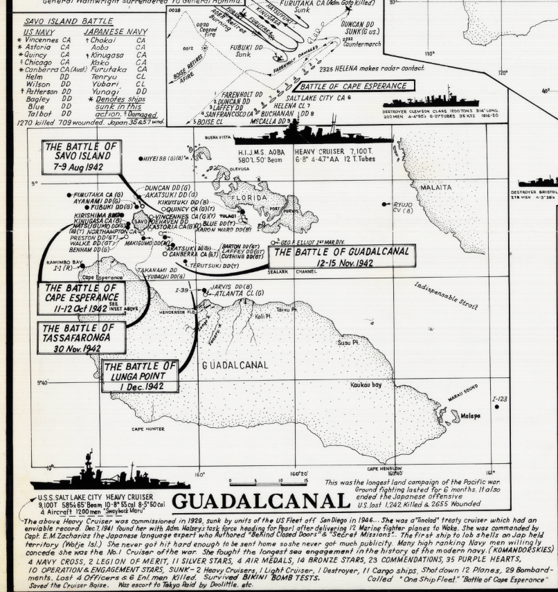
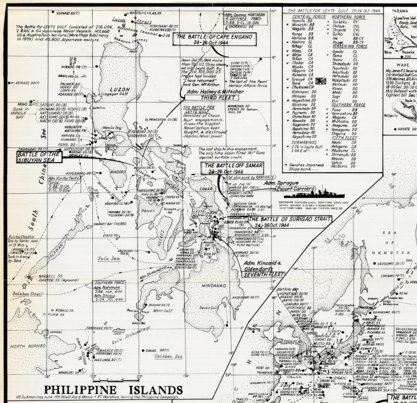
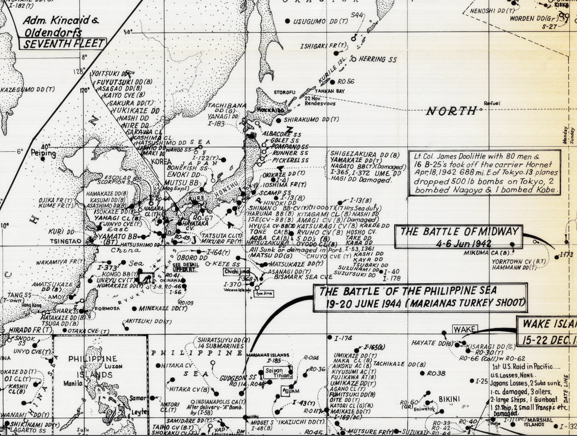
Trace the full arc of the Pacific War with this detailed World War II map documenting U.S. naval operations across the Pacific Ocean. This historic military map presents the Pacific Campaign as a connected sequence of battles, invasions, and fleet movements, illustrating how Allied naval power advanced from Pearl Harbor to the doorstep of Japan.
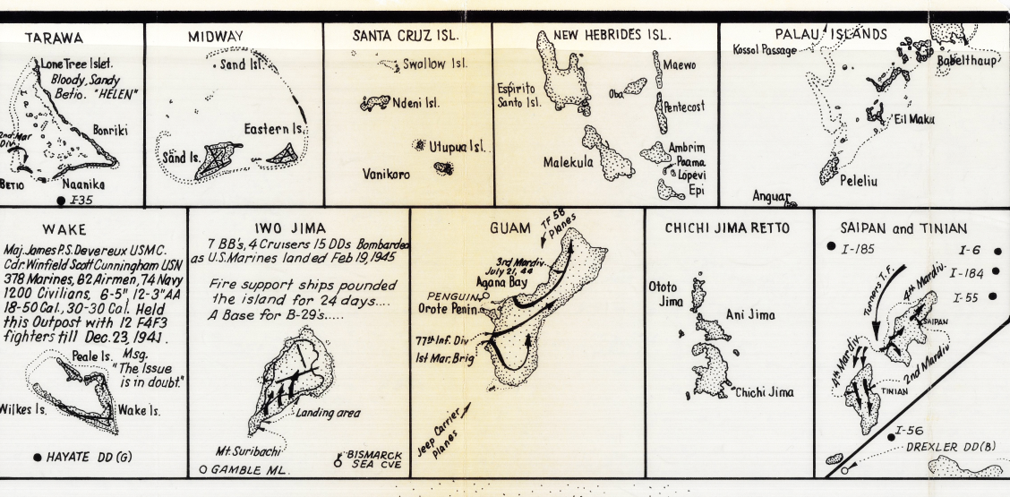
Historical Context This map captures the Pacific Campaign as it unfolded from December 1941 through 1945, following the attack on Pearl Harbor and the rapid expansion of Imperial Japanese forces across the Pacific. As the war progressed, U.S. and Allied forces executed a strategy of island-hopping, bypassing heavily fortified positions while seizing key islands to establish airfields, naval bases, and supply hubs.
Rather than focusing on a single engagement, this map presents the Pacific War as a theater-wide naval and amphibious campaign, emphasizing the central role of sea power in achieving Allied victory.
The Map’s Features This U.S. Naval Operations map is exceptionally information-dense and includes:
• The full Pacific basin from Asia to the western coast of North America
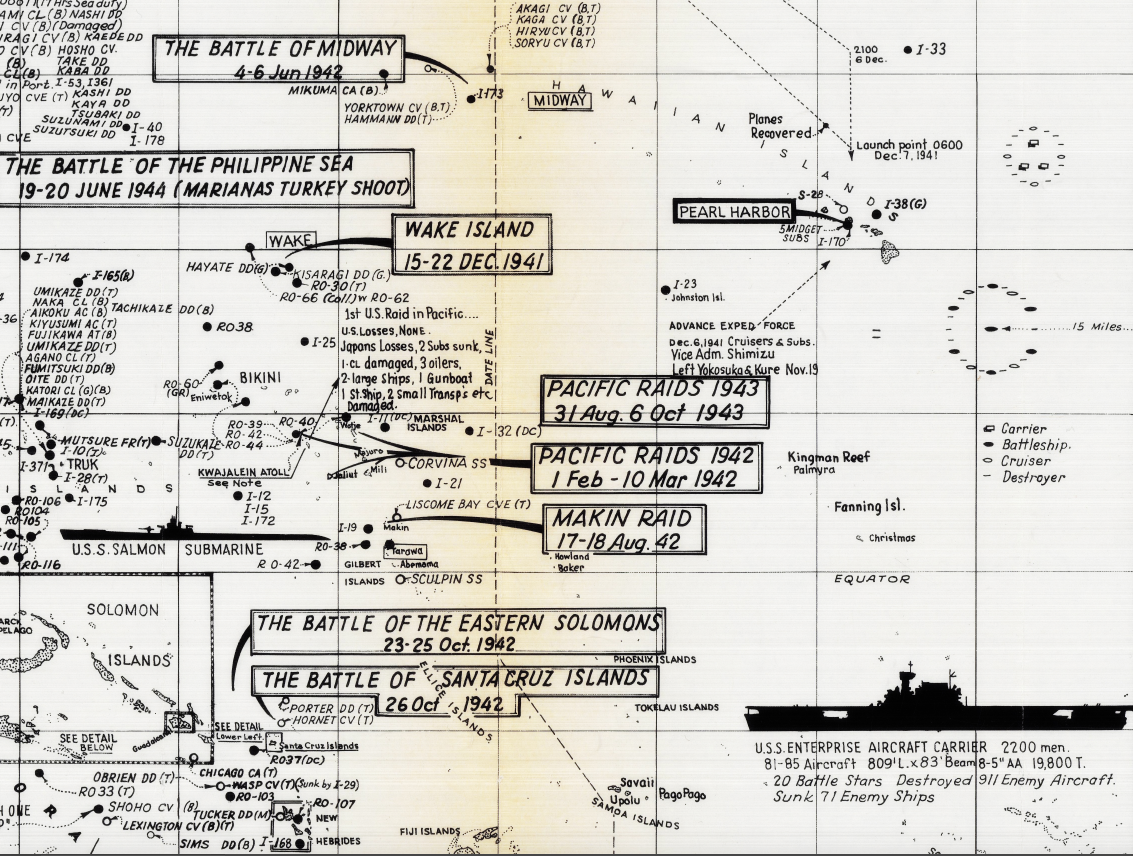
• Major naval and amphibious battles annotated with dates and descriptions
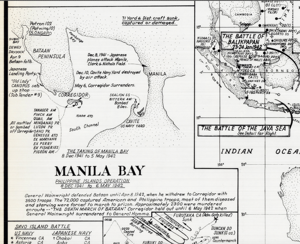
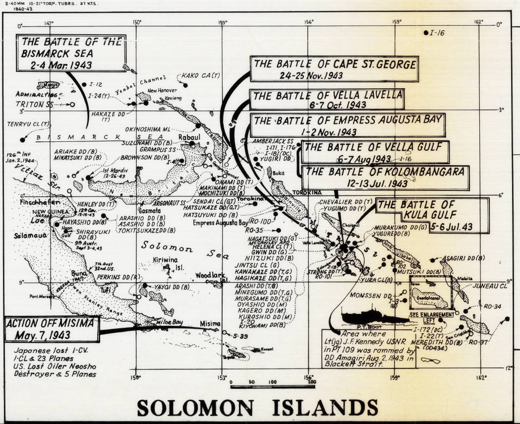
• Key campaign areas including the Philippine Islands, Solomon Islands, Guadalcanal, Okinawa, and Iwo Jima
• Inset maps highlighting critical engagements such as Pearl Harbor, Manila Bay, and island assault operations
• Arrows and movement lines showing the progression of Allied advances
• Chronological battle listings tied directly to geographic locations
• Legends and explanatory text detailing fleet actions and campaign outcomes
The combination of geographic scale and detailed annotation makes this map both a visual overview and a historical reference.
Historical Significance The Pacific Campaign was defined by naval dominance, logistics, and coordinated amphibious warfare on a scale never before seen. This map preserves how the U.S. Navy projected power across immense distances, linking individual battles into a coherent campaign that culminated in the defeat of Japan. For historians and collectors, it offers a rare, integrated view of the Pacific War as a single, evolving operational effort.
Museum-Quality Reproduction This is a high-quality reproduction of the original World War II naval operations map, professionally printed using museum-grade methods and materials to preserve every detail of this complex historic document. Each piece is produced on archival Hahnemühle paper using the Giclée printing process, ensuring exceptional clarity, durability, and a refined finish suitable for display in any setting.
Perfect For
• World War II and Pacific Campaign historians
• U.S. Navy and naval warfare enthusiasts
• Military professionals and educators
• Strategic and operational map collectors
• Offices, libraries, and study spaces
• Displays focused on naval history and global conflict
Specifications
• Original Publication: Post World War II
• Publisher: United States Navy
• Style: Mid-20th-century strategic naval operations map
• Features: Pacific Campaign overview, major naval battles, island campaigns, fleet movements, inset battle maps, chronological annotations
• Product Type: High-Quality Reproduction Print
• Dimensions (Width x Height): 27 x 25.1
Each map is printed using the finest materials and methods. Your map will be handled with white gloves from start to finish. We use the Giclée printing method on Hahnemühle paper, which produces a clear, extremely detailed, durable map perfect for proud display in your home or office.
Digital watermark does not appear on your purchased map.
Choose options
