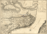
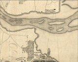
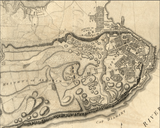
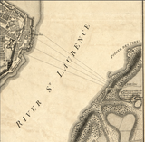
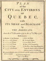


Quebec Siege and Blockade Battle Map
British map showing the "Plan of the City and Environs of Quebec with its Siege and Blockade by The Americans from the 8th of December 1775 to the 13th of May 1776." Also annotated is "M. le Saut du Matelot where Col. Arnold made his attack on the 31st of December and was wounded." Quebec was the Americans offensive attempt to take Canada and were soundly beaten. It was the first major defeat of the Americans in the war. The main part of the battle came on 31 December 1775 with Benedict Arnold leading troops into the Lower City, but were repulsed.
Result: British Victory
Created/Published: 1776
Dimensions (Width x Height): 20x14.5
Each map is printed using the finest materials and methods. Your map will be handled with white gloves from start to finish. We use the Giclee printing method on Hahnemuhle paper, which produces a clear, extremely detailed, durable map that is perfect to be proudly displayed in your home or office.
Digital watermark does not appear on your purchased map.


