Fort Sumter, South Carolina Fortification Map
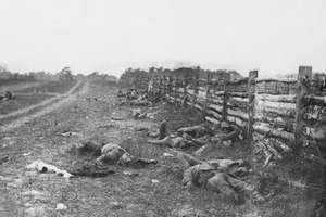
Located in Charleston Harbor where the first shots of the Civil War were fired on 12 April 1861. The fort was surrendered to the Confederacy the following day and stayed in Confederate hands until 1865.
This map contains drawings from all angles of the fort as it appeared to the Union forces bombarding Sumter.
Result: Union Victory (1865)
Created/Published: Sometime in 1860's
Scale: 240 and 600
Dimensions (Width x Height): 29.6x24
Each map is printed using the finest materials and methods. Your map will be handled with white gloves from start to finish. We use the Giclee printing method on Hahnemuhle paper, which produces a clear, extremely detailed, durable map that is perfect to be proudly displayed in your home or office.
Digital watermark does not appear on your purchased map.