


Fort Sumter, Charleston Harbor, South Carolina – April 12–13, 1861 Bombardment Position Battle Map
Fort Sumter, Charleston Harbor, South Carolina – April 12–13, 1861 Bombardment Position Battle Map
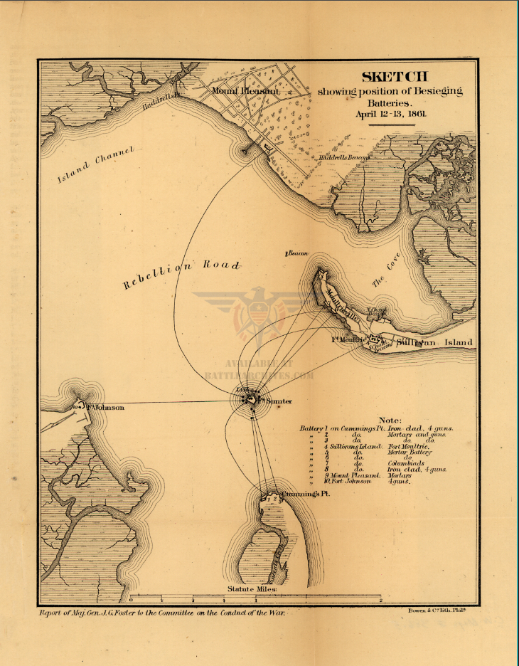
In the pre-dawn hours of April 12, 1861, Confederate artillery opened fire on Fort Sumter from no fewer than ten battery positions ringing Charleston Harbor, inaugurating the American Civil War with a 34-hour bombardment that left the federal garrison no viable choice but surrender. This 1866 operational sketch, drawn for Major General J.G. Foster's official report to the Joint Committee on the Conduct of the War, documents the precise positions, armaments, and firing arcs of each Confederate besieging battery as they converged on the isolated Union fortification. It is among the earliest cartographic records produced by the United States government to formally account for the opening engagement of the war. As both a tactical document and a historical reckoning, this map preserves the geometry of the moment that divided a nation.
Historical Context By April 1861, Fort Sumter had been under a de facto Confederate siege for months, its Union garrison under Major Robert Anderson resupplied only by sea and increasingly cut off from Federal authority. When Confederate General P.G.T. Beauregard's demand for evacuation was refused, his artillery commanders executed a coordinated bombardment from multiple harbor positions—a tactical encirclement designed to suppress the fort's defensive fires and compel capitulation without a costly infantry assault. The battery arrangement documented on this map reflects weeks of Confederate engineering preparation: iron-clad floating batteries, mortar emplacements, and columbiads positioned at Cummings Point, Sullivan's Island, Fort Moultrie, Mount Pleasant, and Fort Johnson formed a ring of fire from which there was no practical relief. Anderson surrendered on April 13, 1861, and the fort passed to Confederate control without the loss of a single man in combat on either side—a deceptively bloodless opening to the war's four years of catastrophic attrition.
The Map's Features The sketch presents Charleston Harbor in profile, centering Fort Sumter at the convergence of ten numbered firing lines that radiate outward to each Confederate battery position. An annotated key in the lower right identifies the armament at each emplacement: iron-clad batteries mounting four guns at Cummings Point, mortar batteries and columbiads distributed across Sullivan's Island and Fort Moultrie, and additional mortar and gun positions at Mount Pleasant and Fort Johnson. Topographic contour lines define the surrounding islands and shoreline, while the labeled waterways—Island Channel and Rebellion Road—establish the full geographic context of the harbor. The scale bar at the bottom, measured in statute miles, allows precise assessment of the distances across which Confederate ordnance was delivered. The cartouche credits Bowen & Co. Lithographers, Philadelphia, confirming this as a professionally produced document within a formal congressional report.
Historical Significance The bombardment of Fort Sumter is the single most consequential military engagement in American history measured by the conflict it initiated. This map, produced for congressional review five years after the event, represents the Federal government's formal effort to understand and document the tactical mechanics of that opening salvo. For military historians, the battery positions recorded here illustrate a sophisticated Confederate encirclement strategy that compensated for the garrison's fortified position through coordinated cross-fire rather than direct assault. For collectors, it is a primary source document—one step removed from the battlefield itself—that captures how the United States government chose to remember and record the moment the Civil War began.
Museum-Quality Reproduction This is a high-quality reproduction of the original historic map, professionally printed on archival Hahnemühle paper using the Giclée printing process to preserve fine cartographic detail, line clarity, and period authenticity for long-term display.
Perfect For:
- Civil War historians and collectors of primary government military documents
- Students of 19th-century artillery tactics and harbor defense strategy
- Veterans, military families, and those with personal ties to South Carolina history
- Offices, studies, libraries, and heritage display collections
- Gifts commemorating the opening engagement of the American Civil War
Specifications:
- Original Publication: 1866
- Publisher: Bowen & Co. Lithographers, Philadelphia; Report of Maj. Gen. J.G. Foster to the Committee on the Conduct of the War
- Style: Operational bombardment position sketch map
- Battle/Conflict: First Battle of Fort Sumter (American Civil War)
- Battle Result: Confederate Victory
- Product Type: High-Quality Reproduction Print
Dimensions (Width x Height): 15 x 19.4
Each map is printed using the finest materials and methods. Your map will be handled with white gloves from start to finish. We use the Giclée printing method on Hahnemühle paper, which produces a clear, extremely detailed, durable map perfect for proud display in your home or office.
Choose options
